|
Day
6, Saturday
In
the morning, we decided to explore the rest of Sheep's Head
Peninsula. We
continued on around the coastline toward the point.
We could see across the bay to the fifth and southernmost
of the peninsulas, Mizen Head.
Maybe we will hit that one on our next trip!
Almost
immediately, we discovered a castle for sale!
It was quite a small and cozy one, an old watchtower,
called Kilcrohane Castle, right by the water.
There was a for sale sign for it on the gateway.
I have always fantasized about buying a castle in Ireland,
and renovating it to live in. And here was my chance!
|
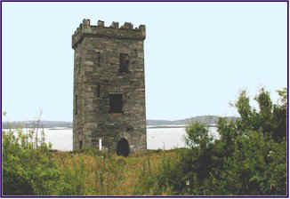
Kilcrohane Castle -
for sale!
|
After further reflection, I decided that Kilcrohane Castle
might be a bit too small, and it was not really in the best area
of the country for horses. Perhaps
I will stick to my original plan, and find a large grand castle up
in County Tipperary somewhere, perhaps at the foot of Slievenamon.
But this one looked like it could be a perfect little
weekend getaway castle!
We followed the narrow winding road out toward the point.
We stopped several times to wait while sheep ambled out of
the way; the road goes right through their grazing areas, and they
are not fenced away from it.
We went out to the end of the road where there is a tiny
village called Toreen, consisting of about four houses.
We parked the car and walked along the hiking trail known
as the Sheep's Head Way. This
is a path that goes all the way around the peninsula; it is marked
by a symbol of a little stick figure man walking, stenciled in
yellow paint on the rocks or fence posts every so often.
We called him the walker, and saw him many times during the
trip!
We
followed the hiking trail along the ridge up to the ruins of
another old signal tower. You
can sit in that high spot and look down and see the water on both
sides at once. You
can also see the other peninsulas in the distance.
The surf was pounding the rocky cliffs far below us, and a
strong wind was blowing. We
were glad we had put on our waxed jackets, as it was quite chilly.
The land was very remote and barren; no trees to speak of,
just rocks and heather, wind, grass and sheep.
It had a unique and amazing beauty all its own.
Once again, we were very glad we had stumbled across
Sheep's Head. It
turned out to be one of the best spots we visited!
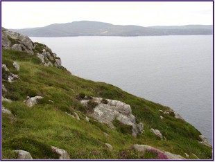 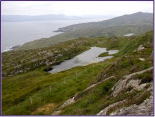
View from the Sheep's
Head Peninsula |
We stopped at a small shop and bought some good Irish
cheese, crackers, cookies and wine.
We drove over a mountain pass aptly named The Goat's
Path. Again, there
were no trees, and the land was very rugged and rocky, with
incredible views from the top; we looked down across the water to
the Beara Peninsula to the north and the Mizen Head to the south.
There was heather and gorse, and some really interesting
flowers that looked exactly like tufts of sheep's wool caught on
twigs. We stopped at
the top and had our picnic, in the car, because it was too windy
and cold to sit out at the picnic tables!
There was a wooden sign at the crest with the Sheep's
Head Peninsula motto: "Water
and Ground in their Extremity."
From here, we headed over to the Beara Peninsula.
As I had been told last year, Beara was very beautiful and
secluded, with fabulous scenery and not too many people.
We skirted around the Bantry Bay, passing through
Ballylickey and Glengarriff, and followed the coastline around to
Adrigole. The landscape was beautiful.
Down along the coast there were some areas of trees, and
many shrubs and flowers. Everywhere
we looked were hedgerows of wild fuchsia in full crimson bloom.
As we went higher up, the land was very unique, steep and
mountainous, with rocks and grass and heather, but almost no
trees. It reminded us
a lot of Connemara, very remote and somewhat desolate, in a wild
and beautiful way.
We
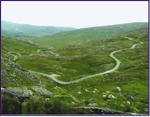
turned inland, and traveled over the Healy Pass. This was incredible! We
followed the narrow road up and up, around the hairpin turns, as
it traversed back and forth up the side of the Adrigole Mountain. We passed stone bridges over swift falling streams and
waterfalls.
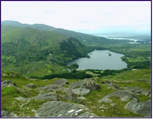
When we got to the top we could look down over the whole
mountainside, and see the winding road like a ribbon below us, and
the Bantry Bay in the distance.
We watched sheep running along sheer rock ledges, very
nimbly negotiating the treacherous slopes.
We stopped at the top and walked among the grassy knolls
and rock formations, and admired the views on both sides, with the
Bantry Bay to the south and the Kenmare River to the north.
|
Healy Pass
|
When we descended from Healy pass we turned westward along
the shore and headed out toward the point.
We noticed at this point that we had put over 700
kilometers on the rental car. (For the metricly challenged, a
kilometer is approximately six tenths of a mile.)
We decided that our goal was to see if we could clock up
1000 kilometers of driving by the time we finished the trip.
Remember, the car had only 46 on it when we started, so
this gave us an odometer target of 1046!
As
it was getting on toward evening, we started the hunt for a
B&B. This turned
out to be even harder than the night before because of a wedding
in Castletownbere, which had booked most of the rooms within a
25-mile radius. We
were advised to travel on around the coast to the town of
Allihies, out near the end of the peninsula.
As
we followed the shore along this route we passed the Coulagh Bay.
Looking out to the water on our right, I suddenly saw sleek
fins slicing through the waves. Dolphins! There
were dolphins in the surf! We
stopped and watched them for the longest time.
There were about a dozen of them feeding near the shore,
and as we watched they came closer.
They started to play, cavorting and leaping out of the
water. It was an incredible time, standing on Ireland's western
shore, watching dolphins frolicking in the last rays of the
setting sun.
Presently the dolphins moved on, and so did we.
We came to the tiny town of Allihies, and found a B&B
right in the town.
After dinner we drove out to the point, where there is a
cable car to Dursey Island. We
had been warned not to ride this cable car, because even though
they do sluice it out after the cows and sheep go across in it, it
is often unreliable, and we might get stranded out on the island.
It did indeed look quite archaic!
The island looked interesting, but by now it was after ten
o'clock at night, and nobody was about.
We noticed a signpost:
Moscow 3310 kilometers!
We appreciated the tongue in cheek humor, and wondered
about the origins of this sign.
Day
7, Sunday
Allihies' claim to fame seemed to be the Copper Mines.
Apparently it was a big copper mining town in the late
1800s. We set out
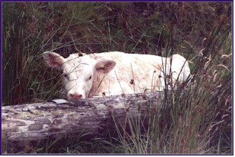
across a cow pasture in
the morning to visit the mines.
|
In the cow pasture
|
First
we came across several smaller mine entrances.
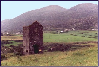
We discovered a small square stone building, quite old, and behind it was a hole in the
ground, well surrounded by a tall and impenetrable barbed wire
fence meant to keep people away from the mineshafts.
We tossed a rock over the fence and into the mineshaft, and
you could hear it bounce off the shaft walls repeatedly, on its
way down, down, down, before eventually making a noise like a
splash at the bottom. Creepy!
As we drove on, we saw probably a dozen other mineshaft
entrances, always strictly fenced off.
Allihies Copper Mines |
We
went in search of the main entrance to the Allihies Copper Mines.
We had seen this structure in numerous pictures in town, at
the Pub and the B&B; it seemed to be Allihies' signature
edifice. As we were
driving along we sighted it close by, part way up the side of the
mountain, so we turned up a lane leading in that direction.
The narrow way wound up the slope towards the mine
entrance, but just when we thought it would take us to the mine
and dead end there, we realized that the lane had bypassed the
mineshaft and was heading up over the mountain pass.
The
lane got narrower and narrower, and more and more windy.
Before long it turned to a gravel track.
The little road continued to climb; we negotiated hairpin
turns and incredibly steep slopes, and sharp rises where you could
not see the road drop down on the far side.
I was somewhat nervous about driving this little lane, as
it was too small to be on the map, and it continued to get smaller
and rougher the further we went.
We didn't know if it would go all the way through, or if
we might find a dead end and have to back up for miles, as
happened to us once on an earlier trip.
Eventually
we reached the top, where we could see the Coulagh Bay in the
distance, and started down the other side.
Soon we came to a wire and orange mesh gate right across
the road. We had to
lift the post out of its socket and drag it to the side to get the
car across, and then replace the gateway.
We weren't sure if the road really continued, or if we
were going to end up in some sheep farmer's back shed.
We continued to anticipate the possibility of miles of
hairpin turns in reverse. But
after continuing on down the little lane we eventually came to a
crossroads where another tiny lane joined our way, and a hand
painted signpost with an arrow pointing to the left, which simply
said 'Pub'! Only
in Ireland!
We went on to the town of Castletownbere, where we visited
the Dunboy Castle. This
was an old ruin of a castle built by Donal Cam O'Sullivan in the
1500s. It has a
fascinating history. During
the siege of Dunboy in 1602, cannon guns battered this castle
down. O'Sullivan
was away at the time, but returned from his travels to find his
castle in ruins. He
set out on foot from Dunboy with 1000 people, many of them wounded
men, elderly, women and children, heading for the town of Leitrim,
600 miles away. They
crossed over the imposing Healy Pass and through much difficult
terrain, enduring severe weather, disease and starvation. Of the 1000 people who started on this desperate journey,
only 35 survived to arrive in Leitrim on January 16, 1603. One of the survivors was O'Sullivan's uncle, Dermot, who
was the historian that recorded their journey.
There is now a marked hiking route called the 'O'Sullivan Beara Way' that follows the course of
O'Sullivan's flight from Dunboy to Leitrim.
Also
near this site was the Puxley Castle, built in 1730 by John
Puxley. His grandson
'Copper John Puxley' moved to Allihies in 1812, and later
added the 'gothic extension' on to the castle, turning it into
a grand country home. In
1921 this structure burned, destroying the roof and many of the
rooms. This seemed to
be the fate of many of the old castles and homes from that era; we
were often hearing or reading about how fire destroyed these
places. But the shell
of Puxley Castle was still beautiful to see!
|

Puxley Castle
|
There was an inlet with a small harbor right below it, and
the remains of the wreck of a large wooden ship lay there, its
curved ribs looking very skeletal in the mostly decayed hull.
Jineen found two lovely sea snail shells; unfortunately the
snails were still in them! We
were concerned that they would stink, but she was determined to
kidnap these defenseless creatures; I think she had a plan for the
removal of the little corpses.
We had a picnic lunch at a little quay down by the water,
and made our travel plans. We
has seen most of Beara by now, it was time to move on.
After all, we still had many kilometers to put on the
rental car! We had
really enjoyed the peninsulas and the coastline; the only trouble
with that area was that castles were in short supply.
We decided that it was time to do some serious castle
hunting! We got our
maps and located every castle marked on them, and planned a route
back towards Limerick that would take us to as many of them as
possible. And we kept
a sharp lookout for uncharted 'everyday castles' along the
way!
As we drove, we sighted a small square castle off to the
right of the road. We
drove partway down a small lane, and walked over a narrow bridge,
and on to the Inchigeelagh Castle on the River Lee.
It was in a farmyard, but nobody was about, so we just
walked through the farm like we owned the place and entered the
castle. We found that
here was an old castle in the process of being restored. There were new wooden
floors on every level, and it was
obvious that work was in process to convert it into a home. How cool that would be!
As we furtively headed back through the farmyard towards
our car we had a little fright; suddenly we heard a snarl and
ferocious barking behind us!
We were very startled and alarmed, but to our relief found
that the vicious guard dog was actually locked in an old slatted
horse trailer. Had we
known of his presence, we wouldn't have been so bold about
entering the farm uninvited!
We went on to Macroom, where a castle was marked on the
map, but it was right in town and way too touristy, so we passed
it by. We preferred
the more out-of-the-way ones!
But outside of town, we sighted yet another of the ancient
square castles. It
was out in the middle of a cow pasture, but built up on a rock
outcropping, in a position that you could tell was very strategic
from a defense standpoint. It
had an iron railing beside the front steps and a plaque showing it
was a National Monument, but unfortunately the doorway was barred
so we could not enter it.
|
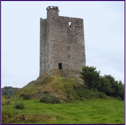
Castle near Macroom
|
We continued on. We
were approaching our goal of 1046 on the odometer!
About 6:30 pm, we arrived at the Kanturk Castle.
It was a fairly large stronghold, beautifully restored with
informational signs around it.
It was built around 1625 by MacDonogh McCarthy of Duhallow.
The
most intriguing thing about Kanturk Castle was on one of the
information signs. It
told how there was a neighboring fortress, called Dromaneen
Castle, 13 kilometers to the southeast.
But it didn't say where!
It
is interesting visiting these castles that are marked on the map
and have been carefully restored and opened to the public,
complete with signs giving history and information.
But somehow they lack the excitement and romance of the
ones we discovered for ourselves!
Dromaneen Castle was one of these discoveries.
Having learned of its existence while in Kanturk, we were
determined to find Dromaneen.
We got out the map and figured out which roads might be 13
kilometers southeast of Kanturk, and drove down them all.
Lo and behold, we saw the castle in the distance; but
getting there was quite another matter!
It
was getting late by this point, so we thought we better begin our
search for the illusive B&B before further adventuring.
Actually, being Sunday, it was easier, and a couple of
calls from a public phone secured us a room at the Riverside House
in Mallow. We had
dinner at the White Deer, a lovely pub that we had enjoyed on a
previous visit. Then
we went out in serious search of the Dromaneen Castle!
We
drove up a small lane that seemed to be in the right direction,
only to find it barred with a metal gate, and a German Shepherd
lying in the road as if on guard.
We then proceeded to drive up every other small road and
lane in the vicinity, looking for a way to get close to this
castle. To no avail!
A Sugar Factory owned most of the lands around the area,
and their 'No Trespassing' signs were very graphic and
strongly worded. We
were just beginning to think it was impossible, when we came
across a couple by the roadway cutting honeysuckle.
We stopped and asked them if there was a way in to the
castle, and they directed us down a small lane.
The very lane we had gone down in the beginning, which was
barred! The
honeysuckle couple informed us that yes, we were allowed to go to
the castle. The
farmer who owned the land had barred the lane, but there was a
public right-of-way through his farm to the castle.
He didn't really like people coming across his land to
visit it, but he did not have the legal right to stop them.
He was allowed to close the gate, but was not allowed to
lock it! We were
psyched; we had been just about ready to give up on getting in to
that castle, but now we were armed with the info we needed!
But by this time it was almost ten o'clock at night, so
we decided to leave any further castle sacking until the morning.
We
returned to our lodging. Having
been unsuccessful in removing the snails from their shells, Jineen
decided to pickle them in a bottle of leftover wine.
Day
8, Monday
Success! We
conquered Dromaneen Castle! We
went back after breakfast and found our way down the little lane
again. And this time
the gate was open! Armed
with the knowledge gained from the honeysuckle pickers, we drove
right up into the farm, left our car in a gateway, and climbed the
farmer's fence into the cow field.
No sign of the farmer, no sign of the German Shepherd.
The
castle itself was fairly large and quite interesting. It had not been restored, so in places the walls were falling
in, and it was very overgrown with weeds and grass. But it was really beautiful!
We wandered from room to room, and tried to recreate in our
minds what it must have looked like when it was an inhabited
fortress.
|
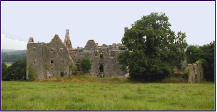
Dromaneen Castle
|
We were constantly amazed at how these National Treasures,
these incredible castles, were practically inaccessible, and
almost impossible to find! There
would be this fabulous ruin of a castle, grand and majestic.
But it wouldn't be on any of the maps or brochures.
There would be no signposts for it, and often no roads to
it. You would park on
the side of the road in a gateway or boreen and walk across some
farmer's field, thinking you might be shot for trespassing; and
when you finally snuck out to the castle, you would find a plaque
showing it was considered a National Monument and was open to the
public. But how the
public would ever be expected to find it was a total mystery!
Dromaneen Castle was a good example of such a place.
I don't know how many visitors it has, but probably not
too many, because it is hard to believe that there are many people
who are as persistent as we were in finding a way to get there!
The people who ran the B&B had told us there was to be
a Horse and Pony Fair in the nearby town of Buttevant that day, so
we decided to go see it. We
had actually stopped by the night before to check out the area,
and had enjoyed talking with a very handsome Garda (policeman) who
was there to prevent problems; he told us quite a lot about the
fair.
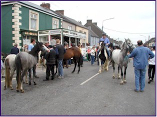
Once
a year, Buttevant closes its streets to car traffic, and holds
this fair. It is
mostly a place where the Traveling people (or Gypsies as we would
call them) come to sell and trade their horses and ponies.
All of the through traffic is rerouted, and people park
their cars in the road and walk into town.
We were warned that if we didn't get there early, we
might have to walk for miles!
The
Garda directing traffic sent us through towards town, and warned
us to lock our car and leave all valuables out of sight.
We rather paranoidly crammed all of our suitcases and
riding gear into the trunk of our car, so the car itself looked
empty! We were there fairly early, so we didn't have to walk far.
And the fair was amazing!
I
have always been fascinated by the lifestyle of the Traveling
people. You will
often see their camps by the side of the road all over Ireland,
with camper style caravans, and horses and ponies tethered by the
roadside to graze. They
travel from place to place, perhaps finding temporary work, often
selling and trading, sometimes stealing, perhaps staying until
local inhabitants drive them out.
They have fairs such as the one in Buttevant, where they
sell to the general public, as well as trading among themselves.
This was a great chance for us to observe the Travelers up
close!
The
entire town was lined with booths, selling everything from
antiques, to shoes, to power tools.
Few cars came through, but the streets were becoming
increasingly crowded with people, horses, ponies and donkeys.
There were horse trailers in side streets, often with up to
a dozen ponies tied to them.
Horses and ponies were tied to car doors, to signposts, and
to each other.
|
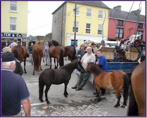 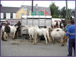
Buttevant Horse and Pony
Fair
|
There were people riding horses up and down the streets,
kids bareback on ponies, and people racing up the road in pony
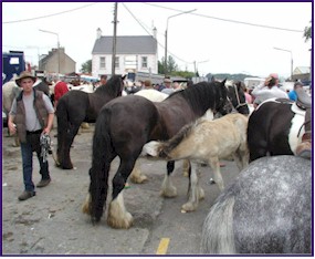
carts and sulkies. Local farmers and horse dealers brought some of the horses
and ponies to the fair, but the majority of them were owned by
Travelers. We saw
some very pretty ponies, though few horses of quality.
There were dozens of what I think of as Gypsy Ponies.
These are large ponies, usually pinto, with a stocky build
and marvelous thick feathers around their pasterns.
We saw a pinto stallion tied on the sidewalk, he was unique
in that he had a huge mustache; something I had never seen before!
We saw mares with foals running loose at their sides,
dozens of donkeys or burros, and a varied assortment of horses.
People were riding many of the horses and ponies up and
down the street showing off their training.
Prospective buyers would get on them to give them a try.
We saw several people come very close to being bucked off
right in the street! Most
of the horses and ponies looked well fed and cared for, but there
were a few that were really pitiful.
The whole thing was somewhat surreal, like a scene out of
the past, something you would have expected to see a century ago:
yet it is a way of life that is still going strong today.
Only in Ireland!
|
Buttevant Horse and Pony
Fair
|
Presently we left the fair, we waved to our friendly Garda on the way out. We
were relieved to find our suitcases still safely crammed in the
boot (Irish for trunk), and we were on our way again.
Next on our agenda was Kilcolman Castle.
This was one that was marked on our map, not far from
Buttevant. We could
see in our atlas that it was located between several small country
roads, sort of in the middle of a five-sided block.
But we could not tell which road would take us the closest.
It proved very hard to find indeed, we could barely see the
top of it from just one spot on the surrounding lanes.
We drove twice around the block before finally just
abandoning the car and setting out across the fields.
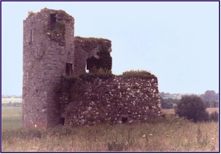
Kilcolman
Castle proved to be quite a challenge! It
stands alone, across three fields.
We climbed the gateway by the road and crossed a sheep
pasture, and then climbed another metal gate, this one made more
demanding by the addition of electric wire. We then went through a hay field and had to find a way to
scramble over another fence, this one consisting of 4 or 5 strands
of barbed wire, with a couple of strands of electric wires thrown
in for good measure, over top of an old tumbled down stonewall.
Then we made our way through high weeds and scrub brush, to
the castle itself. Success
at last: we had arrived at the castle!
As I have mentioned before, the hunt is half the fun.
Invest in the journey!
|
Kilcolman
Castle
|
It proved to be a really neat castle.
We were able to enter it, and we climbed the spiral
staircase right up to the top.
There was sort of a balcony covered in grass about half way
up where we could stand and look across the fields.
This is one of the really interesting things about these
old castles. On the
top floor or roof, there is generally a layer of soil several feet
thick, with grass, shrubs, wildflowers, and even trees growing.
This layer of soil has accumulated over time, since the
castle was built, from dust in the air, bird droppings, and bits
of debris carried on the wind.
So over the ages, impromptu gardens have formed on the tops
of these ancient strongholds.
We headed for the town of Liscarroll.
On the way, we passed the Donkey Sanctuary.
This is apparently a home for rescued or homeless donkeys,
and there were dozens of them grazing in the pasture alongside the
road.
When
we came to Liscarroll, we found that there is a large castle right
in the town. It had
four very high walls, and a padlocked iron gate.
There was a nice little park area just below the fortress
wall. A group of
teenage boys hanging out there told us we could get the key from
O'Brien's pub up in town; but unfortunately nobody was there,
so we did not have success in entering.
We did, however, have a nice little picnic there in the
park below the castle walls.
We had cheese, bread, and a bottle of good white wine.
Unfortunately, we had no corkscrew to open the wine with.
In my attempt to push the cork down into the bottle with a
spoon, I managed to break off the neck of the bottle, leaving a
sharp and jagged glass edge that looked like a weapon!
But fortunately, we could still pour the wine into our
paper cups, and we kept the vicious looking wine bottle concealed
so as not to scare the unwary!
We went on to Rathkeale, where we visited the Castle
Matrix. Again, this was a castle that was on the map, but very
elusive to find. We
drove around the block about three times looking for it.
There was a signpost in town, but none once you get near
the castle; we luckily glimpsed some stone ramparts sticking up
above the trees and used this as our landmark to find the way.
We finally arrived around 5:00 pm.
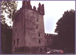
It
was obvious that the castle had been renovated, there were glass
windows, and it looked like somebody lived there.
We stood for some time in indecision; the castle was on the
map and signposted, so it must be open to the public, but we
didn't want to disturb the people who had made it their home.
After a while we got up the nerve to knock on the big
wooden medieval-looking door, and a women came to the door.
And we embarked on another adventure!
|
Castle
Matrix
|
The woman invited us in, and told us some of the history of
Castle Matrix. It was
a very old castle, nobody was sure when it was built.
Her now-deceased husband, Colonel John O'Driscoll, had
renovated it about 25 years ago.
The woman proved to be very spiritual, very much into
numerology and numeric relations, and indeed, somewhat spooky.
She brought us into the first-floor dining room.
We noticed that the light was very dim; indeed, there was
no light inside the castle except for what came in through the
deep-set windows. The
castle was renovated and modernized, but none of the electric
lights were on, and there were candle sconces on the walls, all
unlit. We stood in
this darkling room, full of authentic heavy wooden home
furniture that
had been donated from a monastery, and noticed that above the
fireplace was an extensive collection of weapons: ancient swords,
spears, crossbows, and those spiked balls at the end of a chain.
We felt a distinct sense of unreality.
She offered us a tour of the castle, which sounded
intriguing. We told
her yes, we would love to see the rest of it.
She said she would get her father to give us the tour, as
he enjoyed showing people around.
She left us there and was gone a long time.
Presently she returned, with her father. He was very old, stooped and hunchbacked, and he had the
distinctive trait that one eye could look at me and one eye look
at Jineen, simultaneously! His
hands shook visibly, and he liked to use his hands to emphasize
what he was saying, so this heightened the effect.
I could not help but be reminded of a gargoyle.
The music from The Adams Family kept running through my
head. He beckoned to
us to follow him; he would show us around the castle.
Jineen and I looked at each other skeptically.
Was he going to show us the dungeon?
Would we ever be heard from again?
Actually, once we got used to him, our guide, Anthony
William Forrest, born in Canada, turned out to be an incredibly
nice man. He will be
89 years old this October. He
was very spry and active, and led us up the typical winding stone
spiral staircase. The
rooms in the upper stories were behind big wooden doors with iron
strap hinges, which he unlocked as we entered, and then locked
again after us when we left.
The castle was impeccably restored.
Everything was very authentic.
Huge wooden beams supported the ceilings on each story.
The floors were of flagstone and tile, and the walls were
richly carved in many places.
The rooms had chandeliers of candles.
There was antique furniture from France, Germany, India and
Yugoslavia. There was
a magnificent library upstairs, with thousands of books from all
over the world. There
was fabulous furniture, antique, of heavy wood, with exquisite
carving. There was
even a statue of Sir Walter Raleigh!
Upstairs,
there was a tiny room, formerly occupied by a man and his wife who
had been the caretakers of the castle.
The room was very small, mostly taken up by the large
wood-framed bed from India. Anthony
told us that the couple used to spend most of their time in that
room. When a car drove up, they would open the window and call down
to find out what the visitor wanted, and if they wanted a tour,
then the couple would go down and show them around.
Otherwise, they stayed in their room!
I was afraid to ask what had become of this couple!
Up
another floor, there was a private chapel. The local Priest used to come and conduct services for the
family right there in the castle.
There was a lovely old church bell with a pull rope, and we
got to ring the bell! Anthony
also showed us a secret passageway where there were chains and
shackles attached to the walls.
Ultimately, we came out on the roof, where we had a
fabulous view in all directions.
We decided that this could be a good castle to live in!
We set out on our way back towards Limerick, as sadly, we
had a flight out of Shannon in the morning.
At 6:56 pm, just as we passed the famous Dunraven Arms in
Adare, we met our driving objective, the odometer clicked over to
1046! So subtracting
the 46 on the car when we started, we had driven 1000 kilometers!
We
found great lodging not too far from the airport, at the Mooghaun
Farmhouse. We had
dinner at a pub called The Monk's Well; the food was good, but
it was very slow! We
still had a little daylight left, so we visited the Quin Friary.
An Englishman built it as a castle in the year 1280.
Six years later, in 1286, it was attacked and burned by the
Irish. It was turned
into a Friary in 1433. It
stands right in town, with a little stream running by, and has a
very peaceful atmosphere. We
sat there on the wall of this ancient place and watched the sunset
fade to twilight, our last night in Ireland.
Until the next trip, that is!
Day
9, Tuesday
We got up early and headed to the Shannon Airport.
We returned the car with 1097 kilometers on the odometer,
for a driving total of 1051.
We thought that was pretty good, though the grumpy guy we
returned the car to at the rental place was not too impressed.
"What did you do to it?" he snapped.
Generally
Shannon is not a crowded airport, but because one of the major
Irish airlines had closed down the day before, the lines were
really long, and we barely made it to our flight in time.
As we hastily filled out the Customs and Immigration form,
we saw that along with a whole list of rather vaguely worded
questions about were you carrying large amounts of currency, any
plants, live animals or foodstuffs, it specifically asked if we
were carrying any snails! So Jineen is an International Snail Smuggler!
And I guess that makes me her accomplice!
(Perhaps once they have been sufficiently pickled,
they would be considered escargots rather than snails.)
As much as we enjoyed our trip, it is always nice to return
home. And this time, we had a special treat. Melissa and the working students had painted the show jumps
when we returned! This
was a delightful surprise; the jumps hadn't been painted in
several years and sorely needed it, but we just hadn't had the
time to get it done. Where they found the time while we were gone, I don't know!
But they had done a fabulous job, getting very creative
with color combinations, and had two lovely colorful courses set
up on our return, one in the outdoor arena and one in the indoor.
So much thanks to Melissa, Erin, Kelly, Lin, Mariah and
Emma for this wonderful surprise, and more importantly, for doing
a great job of taking care of Windchase while Jineen and I were
gone.
|
